Evaluating Aerial Data Access for All Corn Growers: NNYADP Research Update
Northern New York; April 12, 2021. Dairy and cash grain producers in northern New York State are participating in research to evaluate if aerial imagery from drones and satellites may enable all farmers, not just those with a yield monitor, to build a corn yield database for their individual farm fields. The farmer-driven Northern New York Agricultural Development Program (NNYADP) is funding the research; Cornell University nutrient management researcher Quirine M. Ketterings, Ph.D., is the project leader.
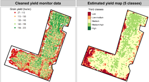
A large regional database has been established as a result of the comparison of yield monitor data provided Regional producers and Champlain Valley Agronomics with drone and satellite imagery data. The project’s latest report is posted at https://nnyagdev.org/index.php/2020-nnyadp-projects.
“The estimated yield maps developed in 2020 on northern New York farms using aerial imagery data from unmanned drones and satellite systems showed promising results, demonstrating the potential to use imagery for mapping yield without the use of yield monitors,” Dr. Ketterings said.
The desired outcome of this research is to develop a standalone tool that uses aerial imagery data to automatically generate corn grain and corn silage yield potentials and yield zone maps for individual farm fields. These maps will help farmers to more precisely allocate manure, fertilizer and seed resources, and to enhance cost-effective agricultural environmental stewardship.
“Not all farms can afford yield-monitoring equipment. If images obtained with unmanned aerial systems can consistently be used to accurately estimate corn grain and silage yields, we can design an approach to give all corn growers access to reliable yield data without the use of that equipment for developing farm-specific yield stability zone management,” Ketterings noted.
![]() Funding for the Northern New York Agricultural Development Program is supported by the New York State Legislature and administered by the New York State Department of Agriculture and Markets.
Funding for the Northern New York Agricultural Development Program is supported by the New York State Legislature and administered by the New York State Department of Agriculture and Markets.